BLOG UPDATES ON FORECAST AND IMPACTS EXPECTED TUESDAY-WEDNESDAY:
—————————————————————————————————————————-
MONDAY 1/20 AM:
TODAY:
A frigid push of air moves in from the north and temperatures over the next few days only top out in the upper 30s and low 40s.
Lows drop to the 20s with wind chill values into the teens.
Keep the warm layers close throughout the week.
TUESDAY:

Tuesday is when we can expect wintry weather to mix into our neighborhoods with precipitation changes from rain to snow to ice to everything in between possible across the Big Bend and South Georgia Tuesday afternoon through Wednesday morning.

The timing and location of precipitation and how it mixes with the different temperatures within our atmosphere will be CRUCIAL to how much ice, snow, and the severity of impacts we experience throughout our neighborhoods.
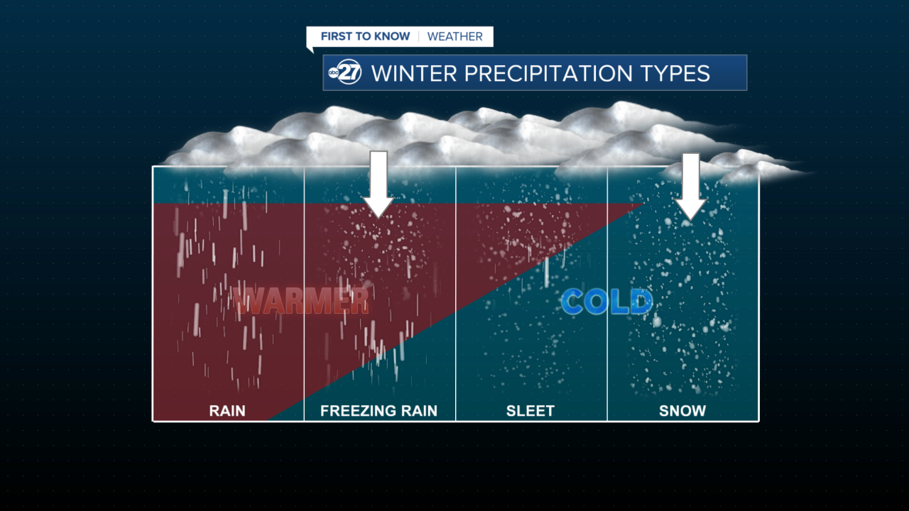
Here is an example of how where we can expect our precipitation types to fall:
We will have a cold upper level atmosphere.
Frozen precipitation will then mix into a warmer mid layer which will melt the frozen precipitation.
Precipitation will interact with a colder layer at surface level which refreezes moisture. This becomes sleet or freezing rain.
Some areas in the tri-state are likely to have a deeper colder layer- meaning not as much melting and refreezing. Ice is still possible on roadways as initial snow melts on contact with surface of warmer asphalt then refreezes into ice.

TYPE OF PRECIPITATION:
Through the tri-state, we are forecast to receive a rain to snow mix with about an 1" or just over of accumulation possible.

Areas through I-10 into the I-75 corridor (Tallahassee to Valdosta line) we can expect a rain to freezing rain to snow event.
This will be the area of the greatest impacts

Areas to our far southeast in southern Taylor, Lafayette, and Suwannee counties will be likely to have some wintry weather mixed in, but primary types of moisture will be rain.

TIMING:
Timing will be the most important factor in what kind of precipitation we get and how much accumulation of snow and/or ice we receive.
The main impacts look to happen late-afternoon Tuesday through Wednesday morning.
Driving during this time will be dangerous and discouraged.
CONFIDENCE LEVELS:
High- There will be moisture moving into our neighborhoods that will mean tricky travel with snow and/or ice accumulation on roadways. Travel will be difficult in areas where ice accumulation is 0.1" or higher on roadways. Excessive ice could mean power outages for our area.
Moderate: Location of precipitation types. Snow is most likely for the tri-state while a snow/freezing rain event is more likely from Tallahassee to Valdosta.
Low: The amount of ice and snow you will wake up to outside of your window 3 miles east of Attapulgus off of Stone Rd. at 4 AM on Wednesday morning. (You get my point). With all transparency, we just will not know how much snow or ice will be outside your window on Wednesday morning.
The amount will vary GREATLY on what happens AS the storm is happening.
A lot of complex storms systems even in Montana we had to do this, so it isn't for the lack of forecasting awareness (believe me I have been there done that with winter weather), but it is just the nature of the system's complexities that make it so difficult to forecast exact totals.
**If/When you see a shift from rain to any other frozen precipitation type Tuesday afternoon through Wednesday morning, expect travel to be tricky/treacherous.
No matter where you are from and how many of your wheels work together or independently, ice is impossible to drive carefully on.
IMPACTS:
Hazardous driving will be likely if rain turns to ice/snow in your neighborhood.
Ice pellets from sleet or freezing rain will freeze on contact with surfaces such as roads, power poles, and branches. Frozen precipitation is heavier than non-frozen precipitation meaning branches and power lines could be stressed and are possible to snap or break.
Power outages are also possible.
Snow and ice will likely melt off roadways by Thursday morning, but some residual snow and ice may be left on less traveled roadways that are shaded through the end of the week.
Here is our historic snowfall for Tallahassee:


