


TALLAHASSEE, Fla. (WTXL) — Heavy snow has already moved into parts of Decatur, Seminole, Miller, Grady, and Gadsden counties Tuesday evening before sunset. Many areas seeing rain will quickly turn over to snow as temperatures continue to fall across the area. While snow is expected to be the main precipitation type from areas Tallahassee to Valdosta northwest, some southeast areas, specifically in Taylor, Lafayette, and Suwannee counties are expected to see mostly freezing rain. This is where ice accumulations and power outages are expected to be the greatest.
Temperatures overnight will continue to fall through the 30s and 20s as feel like temperatures can reach as low as 5 degrees in parts of the area around sunrise Wednesday morning. This has prompted an Extreme Cold Warning to be issued across the Big Bend and South Georgia.
As temperatures fall, more parts of the area will switch to winter precipitation.
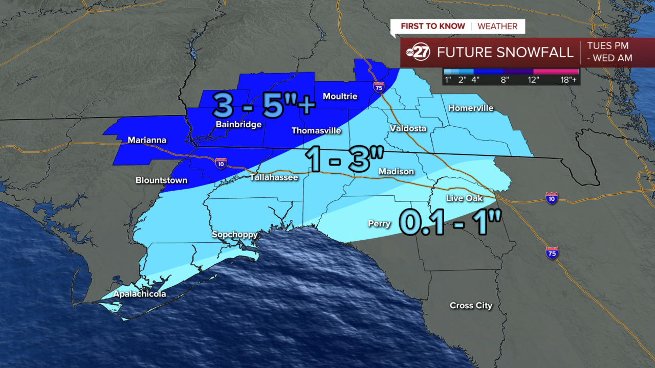
As much as 3-5"+ of snow will accumulate in northwest areas. This includes Gadsden, Decatur, Grady, Miller, and parts of Thomas counties. This is where precipitation will remain mostly snow throughout the night.
The Tallahassee/Valdosta corridor over towards Madison and Homerville is expected to see 1-3" through early Wednesday morning. This includes parts of Wakulla county. This is where a changeover to a mix between rain and snow can happen after midnight.
The Taylor, Lafayette, and Suwannee County area will see less than an inch of snow, but this is where the freezing rain and ice accumulation threat is greatest.

As much as 0.1-0.25" of ice accumulation are expected in freezing rain stretching from eastern Wakulla to Suwannee counties. This is where rain falls as liquid but freezes upon contact with the surface, where temperatures are below freezing. This can also create ice accumulation on powerlines and branches, which can cause power outages.
Precipitation peaks in intensity around midnight before moving out by 3-4am. This is when temperatures will begin to really get cold, with feel-like temperatures staying below freezing the entire day Wednesday with afternoon highs only reaching the mid 30s.
Temperatures below freezing for the next 4 nights will cause any melting snow and ice during the day to be able to refreeze after dark. This can make for slick areas even well after the winter precipitation moves out Wednesday morning.

IMPACTS:
Hazardous driving will be likely if rain turns to ice/snow in your neighborhood.
Ice pellets from sleet or freezing rain will freeze on contact with surfaces such as roads, power poles, and branches. Frozen precipitation is heavier than non-frozen precipitation meaning branches and power lines could be stressed and are possible to snap or break.
Power outages are also possible.
Snow and ice will likely melt off roadways by Thursday morning, but some residual snow and ice may be left on less traveled roadways that are shaded through the end of the week.
Here is our historic snowfall for Tallahassee:

Stay tuned to ABC 27 First To Know Weather throughout the night as we track the minute by minute updates on this rare winter storm.
