

TALLAHASSEE, Fla. (WTXL) — Tropical Storm Helene is churning in the northwest Caribbean Sea Tuesday afternoon, set to achieve hurricane status Wednesday.
Helene's circulation has improved with moisture wrapping around a central low-pressure system. Its peak winds are 70 mph early Monday.
As of Tuesday night the storm was about 150 miles from the western tip of Cuba and as was moving west-northwest at 9 mph.
Helene is expected to enter the Gulf of Mexico Wednesday morning as it strengthens into a hurricane. A major hurricane is still forecast by Thursday afternoon before landfall somewhere in the Big Bend or the northern Nature Coast of the Florida Peninsula.

A Hurricane Warning has been raised for Apalachee Bay and several Big Bend counties, including Leon, Wakulla, Gadsden, and Taylor, among others. This means hurricane-force winds and gusts are possible in the warning zone within 36 hours (mostly likely later Thursday).
A Hurricane Warning also now includes southern Georgia counties. A Tropical Storm Warning is now in effect for Miller and Baker counties.
While hurricane force winds will not be felt throughout the entire warning area, wherever the center of the storm comes ashore will likely see winds that meet that criteria.
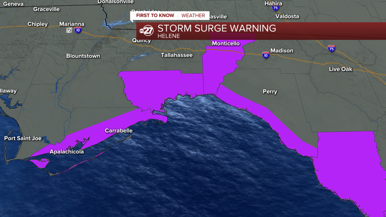
A Storm Surge Warning is in effect for the entire Big Bend coastline. Storm surge totals could be as high as 5-10 feet in Franklin County if peak surge occurs at high tide and the county is on the right side of the storm relative to its movement. Wakulla, Jefferson, and Taylor County coastlines could see 10-15 feet of storm surge above normally dry ground under the same circumstances.

A Flood Watch is in effect for all local counties in anticipation of a widespread area of 3-6 inches of rain. Localized areas could see 10 inches plus where the heaviest rain bands set up. The exact location of the heaviest rain is still uncertain.
A tropical system needs a few things to thrive and strengthen: warm water, low friction/ limited to no land interaction, and low upper level wind (shear).
This system will check all those boxes to strengthen as it moves into the southern Gulf midweek.
The system will move north after entering the southern Gulf, and by late-week, the eastern Gulf Coast will be feeling the impacts from heavy rain, wind, tornado potential, storm surge, and even rip currents in those not directly impacted by the storm.
Landfall potential occurs Thursday afternoon along the northeastern Gulf coast, in or near our region.
Where those direct impacts will be felt is still to be determined. Confidence is growing in a landfall in the Big Bend, however that outcome is not yet set in stone. The storm's movement will more than likely continue within the cone, wobbling from time to time as it moves north.

We are in 'set' stage meaning parts of our area are now under a Hurricane Watch. It would be a good idea to get and prepare supplies for use, stock up on things you may need if without power for a few days, secure property, and notify others of your plans.
Stay tuned to ABC 27 First To Know Weather for the latest on the tropics.
